Learn basic ideas of making new ultra efficient electric motors and generators and how to improve existing patents which use permanent magnets
New Website
Friends
Recomendation
Veljko Milkovic • Inventions, innovations, patents • Self-heating ecological house, Forests for food production • Two-Stage Mechanical Oscillator - Pendulum-Lever System • Petrovaradin Fortress - over and underground, alternative guide service • The Oldest Archaeological Discoveries • The World of Mysteries • Books • Ideas for art, hobby, business...
Veljko Milković is very familiar with Petrovaradin fortress
(city of Novi Sad, Serbia and Montenegro); he has been exploring it since
1960. In 1965 he managed to decipher orientation marks at the crossroads
and establish the logic of subterranean labyrinth with '^', 'Y' and 'T'
crossroads. This approach helps him to examine the 20km deep catacombs of
the fortress in a faster and safer manner.
All the experts and authors that explored the
location agree that the underground of the Petrovaradin fortress is the
biggest attraction of the site.
Four levels of the underground were constructed between
1768 and 1776. The length of the corridors is supposedly 16km, but it seems
that there is more.
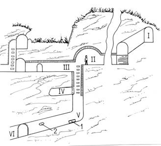
Picture 1. Cross-section of the 'Zdravko's
vertical', which is under the eastern part of the bicorn bastion Hornwerk:
I - A tunnel near the surface with the entry at the St. Elizabeth's powder-room,
II - Lower level, III - Mezzanine, IV - Unfinished corridor, V - The bottom
of the vertical with a stone disc (1) and a place where a shell fossil was
found (2), VI - The lowest level of the unfinished underground
This unique system also had mine fields incorporated,
as well as chambers for soldiers, weapons and 12,000 loop-holes. In the
emergency, underground galleries could have accommodated over 30,000 people.
Two wells were also made in the underground. The larger one was near the
'Gun turret' and was 4m wide and 60m deep (wrongly named 'The Roman well')
and the smaller one - The Emperor Joseph II well is in the underground of
the Hornwerk and is 2m wide and 39m deep (later dubbed 'The Kaiser well').
1780 is mentioned as the year when the Petrovaradin fortress
was finished, although certain underground works lasted for several more
years. However, not everything that was planned was finished (unbricked
corridors, 'earth tunnels', short 'dead-end' corridors etc.).
All the sources so far confirmed that
the underground was used solely for military purposes.
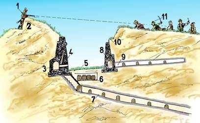
Picture 2. Transversal section of the peripheral wall
of the Petrovaradin fortress: 1 - a defender on the fire line, 2 - the wall,
3 - gallery in the Eskarpa, 4 - Eskarpa, 5 - the ditch, 6 - mine gallery,
7 - deep underground with niches, 8- counter Eskarpa, 9- countermine gallery,
10 - a hidden path, 11 - an attacker on glasija
EXPLORATION OF THE UNDERGROUND
Secrecy and adventurous spirit inspire certain people
to take risks and explore the underground world.PUnderground is
isolated from radio waves, noise and light. Excluded from magnetic waves,
mobiles telephones and transistors have no network coverage...
Under the south part of the Petrovaradin fortress i.e.
bicorn bastion Hornwerk is the majority of underground galleries - tunnels
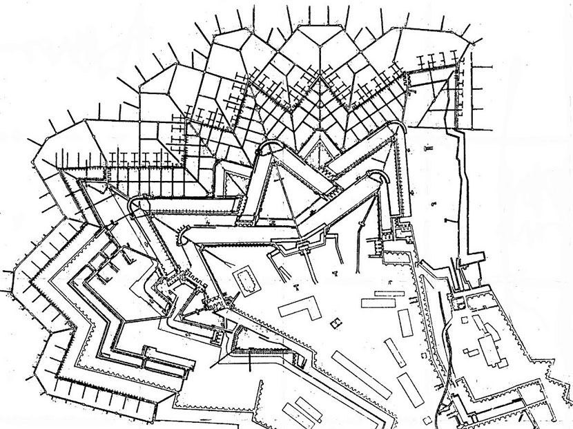
Picture 3. The plan of the Hornwerk underground, southern
part of the Petrovaradin fortress
Possibility of getting lost is the biggest in the deep
underground with stale air and tunnels of smaller dimensions. However, there
is a beneficial point which must be taken into consideration. These are
signs and regularity of intersections.
INTERSECTIONS AND UNDERGOUND CORRIDORS
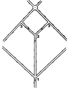
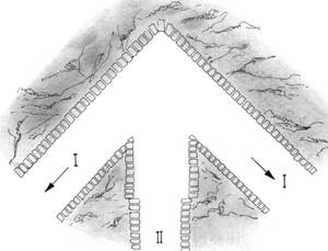
Picture 4. Horizontal view of the typical fragment of
the deep underground of the Hornwerk (south of the Petrovaradin fortress
- behind the Art Academy) with arrow (1), 'Y' shaped (2) and 'T', 'hammer'
(3) intersections. Small arrows, only in pictures, show the way towards
bigger rooms and the exit. Way towards the exit was found in 1965, when
Veljko Milković discovered the regularity of the labyrinth - probably the
biggest secret of the fortress.
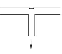
Picture 5. 'T' intersection, if all branches are the
same dimensions - the rule can be applied
Picture 6. Horizontal view of the intersection between
the first and the second level of the underground: I - the first level,
arrows show the way out, II - the second level is 20 cm lower and 40 cm
narrower than the first level. There is slight sloping and exceptions because
of the configuration of the terrain
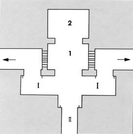
Picture 7. Horizontal view of the underground intersection
with halls: I - The first level, arrows show the way out, II - The second
level of the deep underground, 1 - A guard-house with inner loop-holes,
2 - rest room, cellar...
Note: Arrows and numbers in the pictures 6. and 7. are on
the sketch only for instruction purposes and all published information should
not be taken likely!!!
Problems are bigger with the system shown, because there
is a tendency of bricking up certain tunnels. It should also be kept in
mind that at the 'Y' intersection ( Picture 4 , mark 2) one should
follow a longer branch and judge the conditions correctly
Regularity or signs of the intersections can
decrease the danger of getting lost in the underground. The fact that people
are writing all kinds of additional signs on the walls is not helping when
orientation is concerned.
You can see pictures of the underground in the chapter
PHOTOGRAPHES..